
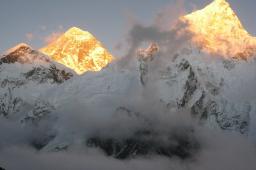
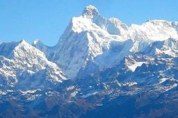
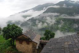
Overview
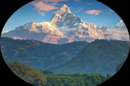
Mount Everest , also called Sagarmatha (Nepali meaning Head of the Sky ) or Chomolungma ,Qomolangma or Zhumulangma (in Tibetan: is the highest mountain on Earth, as measured by the height of its summit above sea level, which is 8,848 metres (29,029 ft). The mountain, which is part of the Himalaya range in High Asia, is located on the border between Sagarmatha Zone, Nepal, and Tibet, China. The highest mountain in the world attracts climbers of all levels, from well experienced mountaineers to novice climbers willing to pay substantial sums to professional mountain guides to complete a successful climb. The mountain, while not posing substantial technical climbing difficulty on the standard route (other eight-thousanders such as K2 or Nanga Parbat are much more difficult), still has many inherent dangers such as altitude sickness, weather and wind. By the end of the 2007 climbing season, there had been 3,679 ascents to the summit by 2,436 individuals. Everest has claimed 210 lives, including eight who perished during a 1996 storm high on the mountain. Conditions are so difficult in the death zone that most corpses have been left where they fell, some of which are visible from standard climbing routes.
• Naming & Measurement
• Climbing routes
• Early Expeditions
• First successful ascent by Tenzing and Hillary
• First ascents without supplemental oxygen
• 2005 - Helicopter landing
• 2006 - David Sharp controversy
• 2008 - Summer Olympic torch summit
• Various records
• Death Zone
• Using bottled oxygen
• Flora and Fauna
• Geology
• Trip Facts & HNT's Climbing Itinerary
Book this Trip
Naming
The Tibetan name for Mount Everest is Chomolungma or Qomolangma which means "Saint Mother"), and the Chinese transliteration is Zhumùlangma Feng (which refers to Earth Mother; the Chinese translation is Shèngmu Feng which refers to Holy Mother.
In 1865, the mountain was officially given its English name by the Royal Geographical Society after being proposed by Andrew Waugh, the British Surveyor General of India. Waugh chose to name the mountain after George Everest. In the early 1960s, the Nepalese government gave Mount Everest the official name Sagarmatha .
This name had not previously been used; the local inhabitants knew the mountain as Chomolungma . The mountain was not known and named in ethnic Nepal (that is, the Kathmandu valley and surrounding areas). The government set out to find a Nepalese name for the mountain because the Sherpa/Tibetan name Chomolangma was not acceptable, as it would have been against the idea of unification (Nepalization) of the country.
Measurement
In 1856, Andrew Waugh announced Everest (then known as Peak XV) as 29,002 feet (8,840 m) high, after several years of calculations based on observations made by the Great Trigonometric Survey.
More recently, the mountain has been found to be 8,848 metres (29,029 ft) high, although there is some variation in the measurements. On 9 October 2005, after several months of measurement and calculation, the PRC's State Bureau of Surveying and Mapping officially announced the height of Everest as 8,844.43 m ± 0.21 m (29,017.16 ± 0.69 ft). They claimed it was the most accurate and precise measurement to date. This height is based on the actual highest point of rock and not on the snow and ice covering it. The Chinese team also measured a snow/ice depth of 3.5 m, which is in agreement with a net elevation of 8,848 m. The snow and ice thickness varies over time, making a definitive height of the snow cap impossible to determine.
The elevation of 8,848 m (29,029 ft) was first determined by an Indian survey in 1955, made closer to the mountain, also using theodolites. It was subsequently reaffirmed by a 1975 Chinese measurement. In both cases the snow cap, not the rock head, was measured. In May 1999 an American Everest Expedition, directed by Bradford Washburn, anchored a GPS unit into the highest bedrock. A rock head elevation of 8,850 m (29,035 ft), and a snow/ice elevation 1 m (3 ft) higher, were obtained via this device. Although it has not been officially recognized by Nepal, this figure is widely quoted. Geoid uncertainty casts doubt upon the accuracy claimed by both the 1999 and 2005 surveys.
A detailed photogrammetric map (at a scale of 1:50,000) of the Khumbu region, including the south side of Mount Everest, was made by Erwin Schneider as part of the 1955 International Himalayan Expedition, which also attempted Lhotse. An even more detailed topographic map of the Everest area was made in the late 1980s under the direction of Bradford Washburn, using extensive aerial photography.
It is thought that the plate tectonics of the area are adding to the height and moving the summit northeastwards. Two accounts suggest the rates of change are 4 mm (0.16 in) per year (upwards) and 3-6 mm (0.12-0.25 in) per year (northeastwards), but another account mentions more lateral movement (27 mm/1.1 in), and even shrinkage has been suggested.
The Mount Everest region, and the Himalayas in general, are thought to be experiencing ice-melt due to global warming.
Climbing routes
Mt. Everest has two main climbing routes, the southeast ridge from Nepal and the northeast ridge from Tibet, as well as many other less frequently climbed routes. Of the two main routes, the southeast ridge is technically easier and is the more frequently-used route. It was the route used by Edmund Hillary and Tenzing Norgay in 1953 and the first recognised of fifteen routes to the top by 1996.
Most attempts are made during May before the summer monsoon season. As the monsoon season approaches, a change in the jet stream at this time pushes it northward, thereby reducing the average wind speeds high on the mountain. While attempts are sometimes made after the monsoons in September and October, when the jet stream is again temporarily pushed northward, the additional snow deposited by the monsoons and the less stable weather patterns (tail end of the monsoon) makes climbing more difficult.
Southeast ridge
The ascent via the southeast ridge begins with a trek to Base Camp at 5,380 m (17,700 ft) on the south side of Everest in Nepal. Expeditions usually fly into Lukla (2,860 m) from Kathmandu and pass through Namche Bazaar. Climbers then hike to Base Camp, which usually takes six to eight days, allowing for proper altitude acclimatization in order to prevent altitude sickness. Climbing equipment and supplies are carried by yaks, dzopkyos (yak hybrids) and human porters to Base Camp on the Khumbu Glacier. When Hillary and Tenzing climbed Everest in 1953, they started from Kathmandu Valley, as there were no roads further east at that time.
Climbers will spend a couple of weeks in Base Camp, acclimatizing to the altitude. During that time, Sherpas and some expedition climbers will set up ropes and ladders in the treacherous Khumbu Icefall. Seracs, crevasses and shifting blocks of ice make the icefall one of the most dangerous sections of the route. Many climbers and Sherpas have been killed in this section. To reduce the hazard, climbers will usually begin their ascent well before dawn when the freezing temperatures glue ice blocks in place. Above the icefall is Camp I at 6,065 metres (19,900 ft).
From Camp I, climbers make their way up the western base of the Lhotse face, where Camp II or Advanced Base Camp (ABC) is established at 6,500 m (21,300 ft). The Western Cwm is a relatively flat, gently rising glacial valley, marked by huge lateral crevasses in the centre which prevent direct access to the upper reaches of the Cwm. Climbers are forced to cross on the far right near the base of Nuptse to a small passageway known as the "Nuptse corner". The Western Cwm is also called the "Valley of Silence" as the topography of the area generally cuts off wind from the climbing route. The high altitude and a clear, windless day can make the Western Cwm unbearably hot for climbers.
From ABC, climbers ascend the Lhotse face on fixed ropes up to Camp III, located on a small ledge at 7,470 m (24,500 ft). From there, it is another 500 metres to Camp IV on the South Col at 7,920 m (26,000 ft). From Camp III to Camp IV, climbers are faced with two additional challenges: The Geneva Spur and The Yellow Band. The Geneva Spur is an anvil shaped rib of black rock named by a 1952 Swiss expedition. Fixed ropes assist climbers in scrambling over this snow covered rock band. The Yellow Band is a section of interlayered marble, phyllite, and semischist which also requires about 100 metres of rope for traversing it.
On the South Col, climbers enter the death zone. Climbers typically only have a maximum of two or three days they can endure at this altitude for making summit bids. Clear weather and low winds are critical factors in deciding whether to make a summit attempt. If weather does not cooperate within these short few days, climbers are forced to descend, many all the way back down to Base Camp.
From Camp IV, climbers will begin their summit push around midnight with hopes of reaching the summit (still another 1,000 metres above) within 10 to 12 hours. Climbers will first reach "The Balcony" at 8,400 m (27,600 ft), a small platform where they can rest and gaze at peaks to the south and east in the early dawn light. Continuing up the ridge, climbers are then faced with a series of imposing rock steps which usually forces them to the east into waist deep snow, a serious avalanche hazard. At 8,750 m (28,700 ft), a small table-sized dome of ice and snow marks the South Summit.
From the South Summit, climbers follow the knife-edge southeast ridge along what is known as the "Cornice traverse" where snow clings to intermittent rock. This is the most exposed section of the climb as a misstep to the left would send one 2,400 m (8,000 ft) down the southwest face while to the immediate right is the 3,050 m (10,000 ft) Kangshung face. At the end of this traverse is an imposing 12 m (40 ft) rock wall called the "Hillary Step" at 8,760 m (28,740 ft).
Hillary and Tenzing were the first climbers to ascend this step and they did it with primitive ice climbing equipment and without fixed ropes. Nowadays, climbers will ascend this step using fixed ropes previously set up by Sherpas. Once above the step, it is a comparatively easy climb to the top on moderately angled snow slopes - though the exposure on the ridge is extreme especially while traversing very large cornices of snow. With increasing numbers of people climbing the mountain in recent years, the Step has frequently become a bottleneck, with climbers forced to wait significant amounts of time for their turn on the ropes, leading to problems in getting climbers efficiently up and down the mountain. After the Hillary Step, climbers also must traverse a very loose and rocky section that has a very large entanglement of fixed ropes that can be troublesome in bad weather. Climbers will typically spend less than a half-hour on "top of the world" as they realize the need to descend to Camp IV before darkness sets in, afternoon weather becomes a serious problem, or supplemental oxygen tanks run out.
Northeast ridge
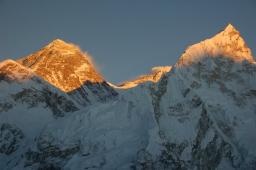
Everest North Face, Tibet, China
The northeast ridge route begins from the north side of Everest in Tibet autonomus region of peoples republic of China. Expeditions trek to the Rongbuk Glacier, setting up Base Camp at 5,180 m (16,990 ft) on a gravel plain just below the glacier. To reach Camp II, climbers ascend the medial moraine of the east Rongbuk Glacier up to the base of Changtse at around 6,100 m (20,000 ft). Camp III (ABC - Advanced Base Camp) is situated below the North Col at 6,500 m (21,300 ft). To reach Camp IV on the north col, climbers ascend the glacier to the foot of the col where fixed ropes are used to reach the North Col at 7,010 m (23,000 ft). From the North Col, climbers ascend the rocky north ridge to set up Camp V at around 7,775 m (25,500 ft). The route crosses the North Face in a diagonal climb to the base of the Yellow Band reaching the site of Camp VI at 8,230 m (27,000 ft). From Camp VI, climbers will make their final summit push. Climbers face a treacherous traverse from the base of the First Step: 27,890 feet - 28,000 feet, to the crux of the climb, the Second Step: 28,140 feet - 28,300 feet. (The Second Step includes a climbing aid called the "Chinese ladder", a metal ladder placed semi-permanently in 1975 by a party of Chinese climbers. It has been almost continuously in place since, and is used by virtually all climbers on the route.) Once above the Second Step the inconsequential Third Step is clambered over: 28,510 feet - 28,870 feet. Once above these steps, the summit pyramid is climbed by means of a snow slope of 50 degrees, to the final summit ridge along which the top is reached.
Ascents
Early expeditions
In 1885, Clinton Thomas Dent, president of the Alpine Club, suggested that climbing Mount Everest was possible in his book Above the Snow Line .
The northern approach to the mountain was discovered by George Mallory on the first expedition in 1921. It was an exploratory expedition not equipped for a serious attempt to climb the mountain. With Mallory leading (and thus becoming the first European to set foot on Everest's flanks) they climbed the North Col 7,007 metres (22,989 ft). From there, Mallory espied a route to the top, but the party was woefully unprepared for the enormity of climbing any further and descended.
The British returned in 1922. George Finch ("The other George") climbed using oxygen for the first time. He ascended at a remarkable speed — 950 feet (290 m) per hour, and reached an altitude of 8,320 m, the first time a human climbed higher then 8,000m. This feat was entirely lost on the British climbing establishment — except for its "unsporting" nature. Mallory and Col. Felix Norton made a second unsuccessful attempt. Mallory was faulted for leading a group down from the North Col which got caught in an avalanche. Mallory was pulled down too, but seven native porters were killed.
The next Expedition was in 1924. The initial attempt by Mallory and Bruce, was aborted when weather conditions precluded the establishment of Camp VI. The next attempt was that of Norton and Somervell who climbed without oxygen and in perfect weather, traversing the North Face into the Great Couloir. Norton managed to reach 8,558 metres (28,077 ft), though he ascended only 100 feet (30 m) or so in the last hour. Mallory rustled up oxygen equipment for a last-ditch effort. He chose the young Andrew Irvine as his partner.
On 8 June 1924 George Mallory and Andrew Irvine made an attempt on the summit via the North Col/North Ridge/Northeast Ridge route from which they never returned. On 1 May 1999 the Mallory and Irvine Research Expedition found Mallory's body on the North Face in a snow basin below and to the west of the traditional site of Camp VI. Controversy has raged in the mountaineering community as to whether or not one or both of them reached the summit 29 years before the confirmed ascent (and of course, safe descent) of Everest by Sir Edmund Hillary and Tenzing Norgay in 1953. The general consensus among climbers has been that they did not.
In 1933, Lady Houston, a British millionaire ex-showgirl, funded the Houston Everest Flight of 1933 , which saw a formation of aircraft led by the Marquess of Clydesdale fly over the summit in an effort to deploy the British Union Flag at the top.
Early expeditions — such as Bruce's in the 1920s and Hugh Ruttledge's two unsuccessful attempts in 1933 and 1936 — tried to make an ascent of the mountain from Tibet, via the north face. Access was closed from the north to western expeditions in 1950, after the Chinese asserted control over Tibet. In 1950, Bill Tilman and a small party which included Charles Houston, Oscar Houston and Betsy Cowles undertook an exploratory expedition to Everest through Nepal along the route which has now become the standard approach to Everest from the south.
In the spring of 1952 a Swiss expedition, lead by Edouard Wyss-Dunant was granted permission to attempt a climb from Nepal. The expedition established a route through the Khumbu ice fall and ascended to the South Col at an elevation of 7,986 metres (26,201 ft). Raymond Lambert and Sherpa Tenzing Norgay were able to reach a height of about 8,595 metres (28,199 ft) on the southeast ridge, setting a new climbing altitude record. Tenzing's experience was useful when he was hired to be part of the British expedition in 1953. He was born in the Tibetan village of Moyez and raised in Nepal.
First successful ascent by Tenzing and Hillary
In 1953, a ninth British expedition, led by John Hunt, returned to Nepal. Hunt selected two climbing pairs to attempt to reach the summit. The first pair (Tom Bourdillon and Charles Evans) came within 100 m (300 feet) of the summit on 26 May 1953, but turned back after becoming exhausted. As planned, their work in route finding and breaking trail and their caches of extra oxygen were of great aid to the following pair. Two days later, the expedition made its second and final assault on the summit with its second climbing pair, the New Zealander Edmund Hillary and Tenzing Norgay from Nepal. They reached the summit at 11:30 a.m. local time on 29 May 1953 via the South Col Route. At the time, both acknowledged it as a team effort by the whole expedition, but Tenzing revealed a few years later that Hillary had put his foot on the summit first. They paused at the summit to take photographs and buried a few sweets and a small cross in the snow before descending.
News of the expedition's success reached London on the morning of Queen Elizabeth II's coronation. Returning to Kathmandu a few days later, Hunt (a Briton) and Hillary (a subject of Elizabeth, through her role as head of state of New Zealand) discovered that they had been promptly knighted in the Order of the British Empire, a KBE, for the ascent. Tenzing (a subject of the King of Nepal) was granted the George Medal by the UK. Hunt was ultimately made a life peer in Britain, while Hillary became a founding member of the Order of New Zealand.
First ascents without supplemental oxygen
On 8 May 1978, Reinhold Messner (Italy) and Peter Habeler (Austria) made the first ascent without supplemental oxygen, using the southeast ridge route. On 20 August 1980, Messner reached the summit of the mountain solo for the first time, without supplementary oxygen or support, on the more difficult Northwest route via the North Col to the North Face and the Great Couloir. He climbed for three days entirely alone from his base camp at 6,500 metres (21,300 ft).
2005 - Helicopter landing
On 14 May 2005, pilot Didier Delsalle of France landed a Eurocopter AS 350 B3 helicopter on the summit of Mount Everest . (without any witness) and took off after about four minutes. (His rotors were continually engaged, constituting a "hover landing", and avoiding the risks of relying on the snow to support the aircraft.) He thereby set rotorcraft world records, for highest of both landing (de facto) and take-off (formally).
Delsalle had also performed, two days earlier, a take-off from the South Col; some press reports suggested that the report of the summit landing was a misunderstanding of a South Col one.
2006 - David Sharp controversy
Double-amputee climber Mark Inglis revealed in an interview with the press on 23 May 2006, that his climbing party, and many others, had passed a distressed climber, David Sharp, on 15 May, sheltering under a rock overhang 450 metres below the summit, without attempting a rescue. The revelation sparked wide debate on climbing ethics, especially as applied to Everest. The climbers who left him said that the rescue efforts would be useless and only cause more deaths because of how many people it would have taken to pull him off.
Much of this controversy was captured by the Discovery Channel while filming the television program Everest: Beyond the Limit . A crucial decision affecting the fate of Sharp is shown in the program, where an early returning climber (Max Chaya) is descending and radios to his base camp manager (Russell Brice) that he has found a climber in distress. He is unable to identify Sharp, and Sharp had chosen to climb solo without any support, so he did not identify himself to other climbers. The base camp manager assumes that Sharp is part of a group that has abandoned him, and informs his climber that there is no chance of him being able to help Sharp [at 8000+ meters in altitude, barely anyone has the strength to help another man who is only semi conscious, and Max Chaya is only an amateur mountaineer]. As Sharp's condition deteriorates through the day and other descending climbers pass him, his opportunities for rescue diminish: his legs and feet curl from frost-bite, preventing him from walking; the later descending climbers are lower on oxygen and lack the strength to offer aid; time runs out for any Sherpas to return and rescue him. Most importantly, Sharp's decision to forgo all support leaves him with no margin for recovery.
As this debate raged, on 26 May, Australian climber Lincoln Hall was found alive, after being declared dead the day before. He was found by a party of four climbers (Dan Mazur, Andrew Brash, Myles Osborne and Jangbu Sherpa) who, giving up their own summit attempt, stayed with Hall and descended with him and a party of 11 Sherpas sent up to carry him down. Hall later fully recovered. Similar actions have been recorded since, including on 21 May 2007, when Canadian climber Meagan McGrath initiated the successful high-altitude rescue of Nepali Usha Bista.
(Note. Information about above mentioned articles and climbing history of the Mountain are collected from different free media sources and for HNT use only. It does not represent an official data so that if need to correct, we would be grateful to your suggestion & support.)
Please submit yours suggestions or comment about this Expedition: info@nirvanatrekking.com
2008 - Summer Olympic torch summit
Peoples republic of China paved a 130 km (81 mi) gravel road from Tingri County to its Base Camp in order to accommodate growing numbers of climbers on the north side of the mountain. It will become the highest asphalt-paved road in the world. Construction began on 18 June 2007 at a cost of 150 million yuan (US$19.7 million). China also routed the 2008 Olympic Torch Relay over Everest, going up the South Col route and back down the North Col route, on the way to the 2008 Summer Olympics in Beijing. A China Telecom cellular tower near the Base Camp provides phone coverage all the way to the summit.
Various records
According to the Nepalese government, the youngest person to climb Mount Everest was a 15-year-old Sherpa girl, and the youngest foreigner was 18-year-old Californian Samantha Larson in 2007.
The fastest ascent over the northeast ridge was accomplished in 2007 by Austrian climber Christian Stangl, who needed 16h 42min for the 10km distance from Camp III to the summit, just barely beating Italian Hans Kammerlander's record of 17 hours, accomplished in 1996. Both men climbed alone and without supplementary oxygen. The fastest oxygen-supported ascent over the southeast ridge was Nepalese Pemba Dorjie Sherpa's 2004 climb, using 8h 10min for the 17km route. The fastest ascent without supplementary oxygen over the southeast ridge was accomplished by French Marc Batard who needed 22h 30min in 1988.
The oldest climber to successfully reach Mt. Everest's summit is 76-year-old Min Bahadur Sherchan, who did so 25 May 2008 from the Nepal side. Sherchan beat the previous record set in 2007 by 71 year old Katsusuke Yanagisawa.
As part of Everest Skydive 2008, an event of twenty-nine skydivers, three internationally known parachutists became the first to skydive above Everest. Neil Jone, Holly Budge and Wendy Smith were flown to 29,500 feet, 2,500 feet above Everest. From there, they jumped in their thermal suit, oxygen tank and extra-thick parachutes landing back at Shyangboche airport 12,350 feet below.
Death zone
While conditions classifying an area as a death zone apply to Mount Everest (altitudes higher than 8,000 m/26,246 ft), it is significantly more difficult for a climber to survive at the death zone on Mount Everest. Temperatures can dip to very low levels, resulting in frostbite of any body part exposed to the air. Since temperatures are so low, snow is well-frozen in certain areas and death by slipping and falling can also occur. High winds at these altitudes on Everest are also a potential threat to climbers. The atmospheric pressure at the top of Everest is about a third of sea level pressure, meaning there is about a third as much oxygen available to breathe as at sea level.
In May 2007, the Caudwell Xtreme Everest undertook a medical study of oxygen levels in human blood at extreme altitude. Over 200 volunteers climbed to Everest Base Camp where various medical tests were performed to examine blood oxygen levels. A small team also performed tests on the way to the summit.
Even at base camp the low level of available oxygen had direct effect on blood oxygen saturation levels. At sea level these are usually 98% to 99%, but at base camp this fell to between 85% and 87%. Blood samples taken at the summit indicated very low levels of oxygen present. A side effect of this is a vastly increased breathing rate, from 20-30 breaths per minute to 80-90 breaths, leading to exhaustion just trying to breathe
Lack of oxygen, exhaustion, extreme cold, and the dangers of the climb all contribute to the death toll.
People who die during the climb are typically left behind. About 150 bodies have never been recovered. It is not uncommon that corpses are visible from the standard climbing routes
One sometimes deadly phenomenon, however, does not plague climbers as it usually does on mountains — lightning. Lightning does not strike Mount Everest. NASA's lightning detection system does record significant lightning in the Tibet plateau, but none along the high Tibetan mountains, from about 2,000 m (7,000 ft) and above.
Using bottled oxygen
Most expeditions use oxygen masks and tanks above 8,000 m (26,246 ft). Everest can be climbed without supplementary oxygen but this increases the risk to the climber. Humans do not think clearly with low oxygen, and the combination of severe weather, low temperatures, and steep slopes often require quick, accurate decisions.
The use of bottled oxygen to ascend Mount Everest has been controversial. George Mallory himself described the use of such oxygen as unsportsmanlike, but he later concluded that it would be impossible to summit without it and consequently used it. When Tenzing and Hillary made the first successful summit in 1953, they used bottled oxygen. For the next twenty-five years, bottled oxygen was considered standard for any successful summit.
Reinhold Messner was the first climber to break the bottled oxygen tradition and in 1978, with Peter Habeler, made the first successful climb without it. Although critics alleged that he sucked mini-bottles of oxygen - a claim that Messner denied - Messner silenced them when he summited the mountain solo, without supplemental oxygen or any porters or climbing partners, on the more difficult northwest route, in 1980.
The aftermath of the 1996 disaster further intensified the debate. Jon Krakauer's Into Thin Air (1997) expressed the author's personal criticisms of the use of bottled oxygen. Krakauer wrote that the use of bottled oxygen allowed otherwise unqualified climbers to attempt to summit, leading to dangerous situations and more deaths. The 11 May 1996 disaster was partially caused by the sheer number of climbers (34 on that day) attempting to ascend, causing bottlenecks at the Hillary Step and delaying many climbers, most of whom summited after the usual 2 p.m. turnaround time. He proposed banning bottled oxygen except for emergency cases, arguing that this would both decrease the growing pollution on Everest—many bottles have accumulated on its slopes—and keep marginally qualified climbers off the mountain.
The 1996 disaster also introduced the issue of the guide's role in using bottled oxygen. Guide Anatoli Boukreev's decision not to use bottled oxygen was sharply criticized by Jon Krakauer. Boukreev's supporters (who include G. Weston DeWalt, who co-wrote The Climb ) state that using bottled oxygen gives a false sense of security. Krakauer and his supporters point out that, without bottled oxygen, Boukreev was unable to directly help his clients descend. They state that Boukreev said that he was going down with client Martin Adams, but just below the South Summit, Boukreev determines that Adams was doing fine on the descent and so descends at a faster pace, leaving Adams behind. Adams states in The Climb : "For me, it was business as usual, Anatoli's going by, and I had no problems with that."
Flora and fauna
Euophrys omnisuperstes , a minute black jumping spider, has been found at elevations as high as 6,700 metres (22,000 ft), possibly making it the highest confirmed permanent resident on Earth. They lurk in crevices and possibly feed on frozen insects that have been blown there by the wind. It should be noted that there is a high likelihood of microscopic life at even higher altitudes. Birds, such as the bar-headed goose, have been seen flying at the higher altitudes of the mountain, while others such as the Chough have been spotted as high as the South Col (7,920 m), scavenging on food, or even corpses, left over by climbing expeditions.
Geology
Geologists have subdivided the rocks comprising Mount Everest into three units called "formations". Each of these formations are separated from each other by low-angle faults, called “detachments”, along which they have been thrust over each other. From the summit of Mount Everest to its base these rock units are the Qomolangma Formation, the North Col Formation, and the Rongbuk Formation.
From its summit to the top of the Yellow Band, about 8,600 m above sea level, the top of Mount Everest consists of the Qomolangma Formation, which has also been designated as either the Everest Formation or Jolmo Lungama Formation. It consists of grayish to dark gray or white, parallel laminated and bedded limestone interlayered with subordinate beds of recrystallized dolomite with argillaceous laminae and siltstone. Gansser reported finding visible fragments of crinoids in these limestones. Petrographic analysis of samples of this Ordovician limestone from near the summit revealed them to be composed of carbonate pellets and finely fragmented remains of trilobites, crinoids, and ostracods. Other samples were so badly sheared and recrystallized that their original constituents could not be determined. The Qomolangma Formation is broken up by several high-angle faults that terminate at the low angle thrust fault, the Qomolangma Detachment. This detachment separates it from the underlying Yellow Band. The lower five metres of the Qomolangma Formation overlying this detachment are very highly deformed.
The bulk of Mount Everest, between 7,000 and 8,600 m, consists of the North Col Formation, of which the Yellow Band forms its upper part between 8,200 to 8,600 m. The Yellow Band consists of intercalated beds of diopsite-epidote-bearing marble, which weathers a distinctive yellowish brown, and muscovite-biotite phyllite and semischist. Petrographic analysis of marble collected from about 8,300 m found it to consist as much as five percent of the ghosts of recrystallized crinoid ossicles. The upper five metres of the Yellow Band lying adjacent to the Qomolangma Detachment is badly deformed. A 5–40 cm thick fault breccia separates it from the overlying Qomolangma Formation.
The remainder of the North Col Formation, exposed between 7,000 to 8,200 m on Mount Everest, consists of interlayered and deformed schist, phyllite, and minor marble. Between 7,600 and 8,200 m, the North Col Formation consists chiefly of biotite-quartz phyllite and chlorite-biotite phyllite intercalated with minor amounts of biotite-sericite-quartz schist. Between 7,000 and 7,600 m, the lower part of the North Col Formation consists of biotite-quartz schist intercalated with epidote-quartz schist, biotite-calcite-quartz schist, and thin layers of quartzose marble. These metamorphic rocks appear to the result of the metamorphism of deep sea flysch composed of interbedded, mudstone, shale, clayey sandstone, calcareous sandstone, graywacke, and sandy limestone. The base of the North Col Formation is a regional thrust fault called the “Lhotse detachment”.
Below 7,000 m, the Rongbuk Formation underlies the North Col Formation and forms the base of Mount Everest. It consists of sillminite-K-feldspar grade schist and gneiss intruded by numerous sills and dikes of leucogranite ranging in thickness from one cm to 1,500 m.
Itinerary
Day 1: Arrival in KTM & transfer to Hotel
Day 2: Half day sightseeing of Boudhanath, Pahsupatinath & Syambhunath. Evening trek preparation
Day 3: Kathmandu ; final preparation for trek
Day 4: Fly Lukla, trek to Phakding
Day 5: Trek to Namche Bazaar
Day 6: Namche. Rest day/Side trip to Syangbouche/Thame
Day 7: Trek to Tengbouche
Day 8: Trek to Dingbouche
Day 9: Dingbouche. Rest day
Day 10: Trek to Lobouche
Day 11: Trek to Gorekshep
Day 12: Kalapatter to Everst Base camp & back
Day 13 to Day 34 : MT. EVEREST CLIMBING PERIOD
Day 35: Trek to Pheriche
Day 36: Trek to Tengbouche
Day 37: Trek to Menjo
Day 38: Trek to Lukla
Day 39: Fly back to Kathmandu
Day 40: Kathmandu .
Day 41: Final departure to airport
Price
INCLUDES:
Mt. Everest climbing permit from South-East ridge
6 (six ) nights hotel in Kathmandu on BB basis.
Round trip airfare to & from Lukla.
Excess baggage and domestic airport taxes.
Necessary number of porters and yak to carry the Expedition loads
Liaison officer fee
Walkie-talkie set to each client with radio base & accessories.
Satellite phone for emergency purpose
Private tent at Base camp with mattress
Well set up group dinning tent with gas heaters
Comfortable wooden toilet tent at BC & Shower tents
All meals & drinks at Base camp and en-route
Solar panel/generator at base camp for recharging & power supply
Base camp manager
One head Sardar
Cooks and kitchen boys.
Climbing Sherpa (1:1 ratio)
All necessary climbing hardware gears with fixed ropes.
All necessary camping and kitchen gears.
Quality high altitude food
High quality high Altitude tents.
Storage & communication tent
Gammov bag & oxygen with mask set for medical purpose at Base camp
Sleeping bag & down jacket for BC purpose
Necessary number of EPI gas with burner
Russian 4 litre POISK Oxygen (04 bottles each member 3 for sherpa)
Mask and regulator set.
Insurance of climbing Sherpa and local team members
All airport transport & celebration meal in Kathmandu .
EXCLUDES
Medical and personal high risk insurance
Cost of electronic appliances.
Personal climbing gears.
Major meals in Kathmandu .
Cost of personal nature.
Cost of emergency evacuation
Tips & Summit bonus.
OTHERS/EXTRAS IF REQUIRED: cost based on 2008 may differ for current date
Climbing Sherpa : US $ 5000
For Support member: US $ 3,500 Ex. Kathmandu
Extra oxygen: US $ 550per 4 liter
Mask & regulator set $ 450 per set
For further consultation or discussion about this expeditions please write us in the following address: info@nirvanatrekking.com
Trip duration: 41 Days
Grade: Challenging
Trip Code: HNT-EVEREST-SE-EXP41D
Activity: Sightseeing, trekking & Mountaineering
Starts in: Kathmandu
Ends in: Kathmandu
Accommodation: Hotel, camping
Transportation: Flights, private car or tourist bus
Maximum altitude: 8849M (O), 8850M (N)
Related Packages
Popular Trekking


.jpg&w=256&h=170)


.jpg&w=256&h=170)

Popular Expedition


We are Associated With
Travel Information
Contact Us
PO Box: 7569, Bhagwan Bahal Marg, Thamel-26, Kathmandu, Nepal
Tel : +06221924,4438162
Mob: +977-9841389753
Email: info@nirvanatrekking.com
himnirvana@mos.com.np trekkinghimalayan@yahoo.ca
Website: http://nirvanatrekking.com